This guide is an orientation to Key West as a port city, rather than a checklist of island attractions. It draws on published historical accounts, public reference records and the city’s official information; it is not a reporting visit or a claim of firsthand observation. The emphasis is on the connections between waterfront work, Cuban migration, literary memory and the transport systems that changed the island. Familiar sights appear here as evidence of those connections, not as substitutes for the city’s longer and sometimes uncomfortable history.
Why visit Key West
- 01
Read the port beneath the resort image
Nineteenth-century wrecking connected Key West to ships moving through the Florida Straits. The salvage economy gives the waterfront a history more complicated than a picturesque collection of docks.
- 02
Follow the Cuban connection
Cigar factories and migration from Cuba helped shape the city’s working and cultural life. Reading that history alongside the better-known literary houses prevents Old Town from becoming a story only about famous temporary residents.
- 03
Trace the mainland connection
The arrival of the Overseas Railroad in 1912 changed Key West’s relationship with the rest of Florida. Its destruction and partial reuse explain why the road journey is also a journey through railway infrastructure.
- 04
Examine the island’s public symbols
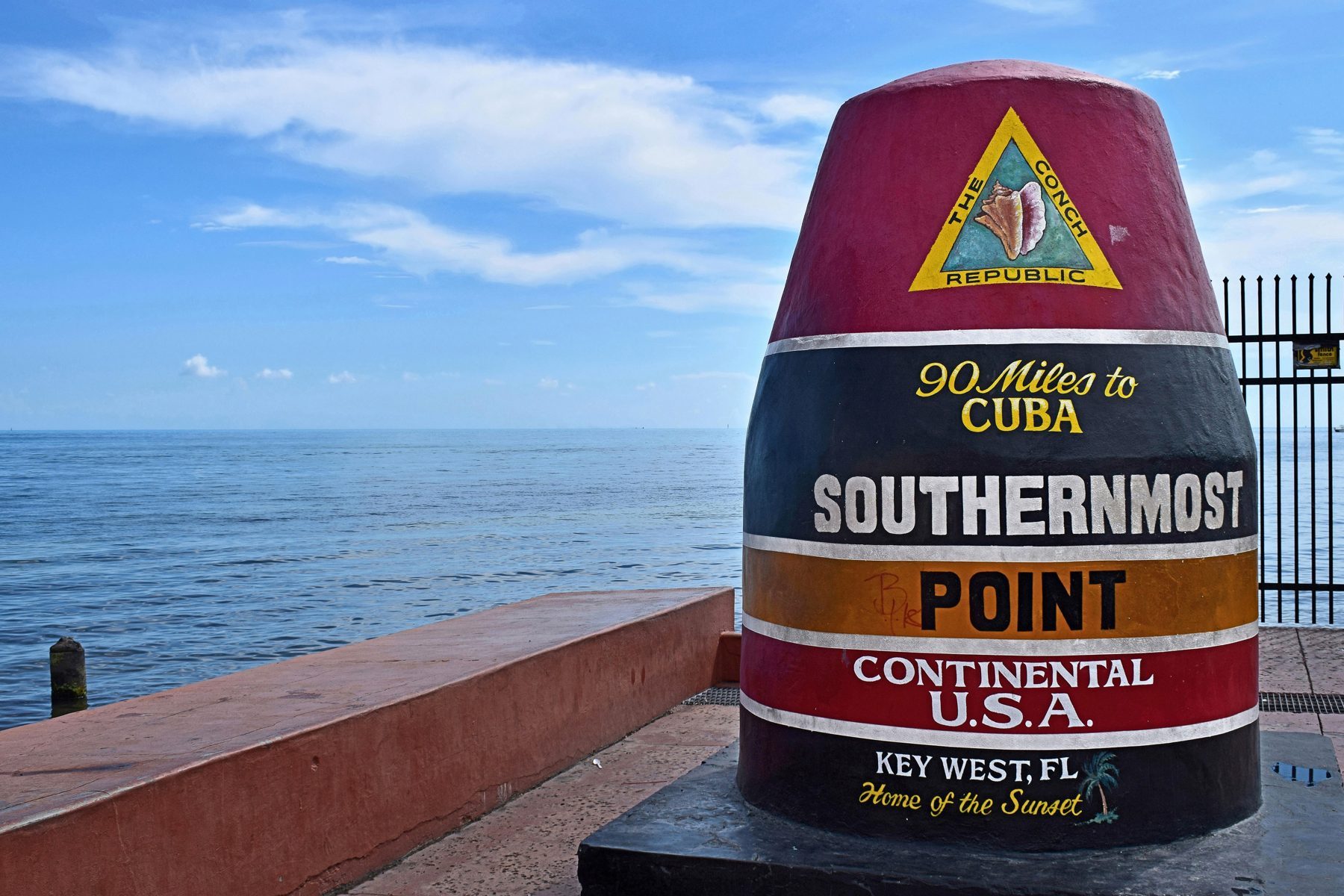
The Southernmost Point buoy and Mile Marker 0 compress geography into photographs. Fort Zachary Taylor offers a different scale of interpretation: an actual coastal defense installation beside the water it was built to command.
History: Cayo Hueso and the business of salvage
The Spanish name Cayo Hueso is usually translated as Bone Key. Accounts connect the name to human remains encountered on the island; the naming tradition should not be mistaken for a fully recoverable account of who left them or why. The English name Key West is not simply a literal translation. Beginning with the Spanish name is useful because it interrupts the impression that the city’s history began with its American-era houses.
In the nineteenth century, wrecking meant recovering vessels and cargo from the dangerous waters around the Keys, not merely collecting objects washed onto a beach. Salvage made the port commercially important. The word can sound romantic, but the underlying economy depended on maritime accidents, specialized local knowledge and the movement of valuable goods through the Florida Straits.
The Overseas Railroad reached Key West in 1912. The 1935 Labor Day hurricane devastated the route, and rail service was not restored. Surviving railway structures later helped carry an expanded Overseas Highway, whose through-road connection was completed in 1938. The highway was therefore not simply a fresh line drawn across empty water: part of its physical inheritance came from a failed railway connection.
Culture and people: factories, writers and presidential rooms
Cuban cigar manufacturing expanded in Key West during the nineteenth century, bringing factories and workers into the city’s daily life. The 1886 fire destroyed factories as well as homes, and some manufacturers moved to Tampa’s Ybor City. This industrial history belongs beside, rather than beneath, the city’s literary reputation. It makes migration and labor central to an understanding of the streets.
Ernest Hemingway’s Whitehead Street house is associated with his residence in the 1930s and is now a museum. The Truman Little White House began as naval housing and later served as President Harry S. Truman’s working retreat. They preserve different kinds of occupancy: one literary and domestic, the other connected to the military establishment and the presidency. Neither house should be treated as a complete account of the surrounding community.
The Conch Republic originated in 1982 as a symbolic declaration of independence protesting a Border Patrol roadblock on the mainland approach to the Keys. It was political theater rooted in a practical concern about interrupted movement and trade, not the establishment of a separate sovereign country. Its persistence as a civic identity says something about a city that repeatedly represents itself through performance.
Landscape and water: fortifications and geographical shorthand
Fort Zachary Taylor stands at Key West’s southwestern edge. Begun before the Civil War, the fort remained in Union hands during that conflict. Its position makes the island’s strategic geography legible: the water around Key West was a route to be watched and controlled, not simply a view. The state park brings coastal recreation and military history into the same landscape.
The Southernmost Point buoy is a commemorative marker, not a survey instrument establishing the southernmost land in the United States. Other land in Key West extends farther south, and Hawaii alone makes a nationwide claim untenable. Mile Marker 0, meanwhile, marks the Key West end of U.S. 1. Read the two as different public signs: one a celebrated geographical shorthand, the other a highway reference point.
Businesses and working economy: beyond the famous address
Tourism is central to contemporary Key West, but the historical sequence matters. Wrecking, cigar making and military activity belong to distinct economic arrangements, not one continuous leisure industry. The literary houses and preserved fort now also operate within a visitor economy that turns former residences and infrastructure into places of interpretation.
For a useful reading of Old Town, distinguish a building’s architectural survival from the survival of its original use. A preserved house can carry a new business, and a waterfront associated with old trades can serve a very different market. This guide does not rank restaurants, charter operators or lodging, nor does it infer their quality from a historic address.
Current conditions: consult the city before making a plan
Use the City of Key West’s official website, https://www.cityofkeywest-fl.gov/, for municipal notices and links to current services. Confirm admission arrangements directly with each museum and check the state park operator before relying on a particular facility. Historical descriptions do not establish today’s opening hours, ticket availability, parking arrangements or shoreline conditions.
Treat the city as the end of a transport corridor rather than an isolated set of attractions. A plan built around one photograph can obscure the distinction between a highway marker, a museum and a park. Choose a small number of places with a clear historical relationship, and leave operational decisions to current official notices rather than this orientation.
Photograph and source record
Photograph: Southernmost point buoy, NE view by Radomianin via Wikimedia Commons, CC BY-SA 4.0: https://commons.wikimedia.org/wiki/File:Southernmost_point_buoy,_NE_view.jpg. This guide is an orientation drawn from the public record and the sources listed below, not a reporting visit.
Addresses for the places in this guide
- Fort Zachary Taylor Historic State Park601 Howard England Way, Key West, FL 33040 · 305-292-6713
- Ernest Hemingway Home & Museum907 Whitehead Street, Key West, FL 33040 · 305-294-1136
- Harry S. Truman Little White House Museum111 Front Street, Key West, FL 33040 · 305-294-9911
- Mile Marker 0490 Whitehead Street, Key West, FL 33040 · 305-809-3945
Where to eat and shop in Key West
A short list of independent local businesses, each checked against its own listing on November 16, 2026. No business paid to be here. Hours change, so call ahead.
Restaurant
El Mesón de Pepe
A family-run Cuban restaurant at Mallory Square.
410 Wall Street, Key West, FL 33040 · 305-295-2620
Restaurant
Thirsty Mermaid
The restaurant serves fresh local seafood and rotating oyster selections.
521 Fleming Street, Key West, FL 33040 · 305-204-4828
Restaurant
Antonia's
An Italian restaurant on Duval Street in Old Town.
615 Duval Street, Key West, FL 33040 · 305-294-6565
Restaurant
Little Pearl
Little Pearl is a neighborhood restaurant and wine bar focused on local seafood.
632 Olivia Street, Key West, FL 33040 · 305-204-4762
Coffee
Keys Coffee Co. — Southard Street
The cafe serves made-to-order breakfast and lunch sandwiches, salads, smoothies, pastries and coffee.
505 Southard Street, Key West, FL 33040 · 305-906-1205
Restaurant
Clemente's Wood-Fired Trolley Pizzeria
A wood-fired pizzeria on Fleming Street serving scratch-made pizza and Italian comfort food.
516 Fleming Street, Key West, FL 33040 · 305-900-7035
Questions readers ask
- What does Cayo Hueso mean?
- Cayo Hueso is commonly translated as Bone Key. The name is associated with accounts of human remains found on the island, but the tradition does not establish all the circumstances behind those remains.
- When did the railroad reach Key West?
- The Overseas Railroad reached Key West in 1912. Rail service ended after the 1935 Labor Day hurricane, and surviving structures were incorporated into the later highway connection.
- Is the Southernmost Point really the southernmost place?
- The buoy is not the southernmost land in the United States, and parts of Key West itself lie farther south. It is more accurately understood as a highly visible public marker than as an exact geographical extreme.
- What is the Conch Republic?
- The name comes from Key West’s symbolic 1982 independence protest against a Border Patrol roadblock. It denotes a civic identity and commemorative tradition, not a separate country.